Fire probability forecasting - WCSSP case study
Through the CSSP Brazil project, researchers are working to understand and reduce the risk from wildfires.
Wildfires are unplanned and uncontrolled fires that can have devastating impacts on society and ecosystems. To improve our understanding on the risks from wildfires, researchers from the CSSP Brazil project are studying what causes wildfires in South America and how they may change in future. Through the project, our Brazilian partners have developed a fire probability forecasting service for South America to provide decision makers with information on the fire probability associated with South America’s protected areas several months in advance.
What is a wildfire?
In comparison to landscape fires that are a natural process and vital for the health of many ecosystems, wildfires are fires that can burn out of control and have serious negative environmental, economic and social impacts. Wildfires can destroy forests and infrastructure and their smoke can lead to poor air quality and contribute to climate change.
How are wildfires changing?
A 2022 report from the United Nations Environment Programme, highlighted that the risk of wildfires in many regions is increasing due to factors such as changes in land use and climate change. Fire weather, when conditions are advantageous to fire ignition and spread, has increased in most regions in recent decades due to climate change. Many areas have seen changes in the locations of wildfires and the lengthening of fire seasons. In South America, the fire season length has increased by an average of 33 days in the last 35 years.
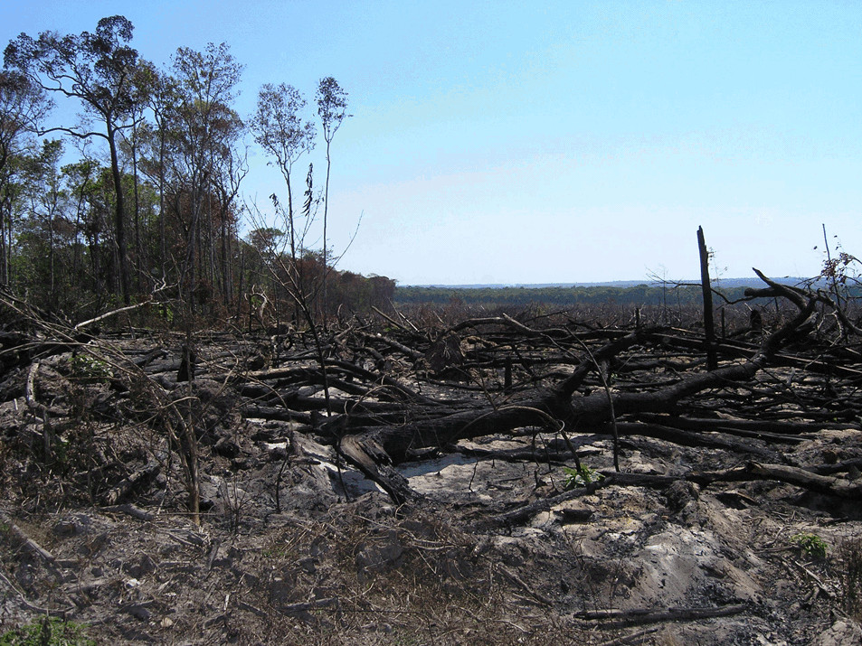
 Burnt trees and vegetation after a fire in Mato Grosso, Brazil. Image: Liana Anderson
Wildfires and the global carbon cycle
When vegetation burns it releases large quantities of greenhouse gases into the atmosphere. As the Amazon rainforest is one of the world’s largest and most important carbon stores, the increase in fire activity in South America could impact the global carbon cycle. CSSP Brazil research led by the Met Office in collaboration with Brazil’s National Centre for Monitoring and Early Warning of Natural Disasters (CEMADEN), used climate models to study how much carbon loss could occur in South America due to wildfires.
“We found that burned area and fire emissions are projected to increase in the future due to hotter and drier conditions, leading to a reduction in carbon storage.” Chantelle Burton, Senior Scientist at the Met Office.
In a scenario where the world continues to rely on fossil fuels leading to an average global temperature rise of 4⁰C, wildfires could cause up to 30% of the carbon stored in South American vegetation to be released into the atmosphere, contributing to climate change. This loss of carbon could be reduced to 7% if the global increase in temperature is limited to 1.5⁰C.

Developing a seasonal fire probability forecast for South America
One of the successful outcomes of the CSSP Brazil project has been the development of a seasonal fire probability forecasting service for South America. Led by CEMADEN in collaboration with the Met Office and the Instituto Nacional de Pesquisas Espaciais (INPE), the project used the Met Office seasonal forecast to analyse temperature and rainfall probability, together with fire trend data, and developed a method of calculating fire probability for South America several months ahead.
The researchers used the seasonal forecast to produce reports for decision makers on fire probability for South America’s protected areas which have high biological, environmental and sociocultural value. Reports are also produced on fire risk to Brazilian municipalities. The forecasts are presented by CEMADEN in regular meetings to firefighters, civil defence workers and other stakeholders in Brazil and the forecasts have been shared with over 130 different organisations in Brazil.
Through identifying areas with increased fire probability and providing recommendations to mitigate that risk, the project is helping generate information to support wildfire strategic prevention and planning that will support conservation strategies across South America. The fire probability forecast has been incorporated into the operational plan for preventing and combating forest fires in the Amolar network - a network of protected areas in Pantanal. This network spans national borders, facilitating strategic planning and fire management across the region.
“The forecast is being used by the Brazilian states of Goiás, Maranhão and Mato Grosso do Sul to guide prevention and mitigation actions. Since August 2021, more than 70 protected areas have received a ‘high alert’ level and more than 1800 at an ‘alert’ level, meaning areas are threatened by fire. “Liana Anderson, CEMADEN.


