The Wessex Convection Experiment (WesCon)
WesCon is a UK summer convection experiment concentrating on understanding dynamical aspects of convection to provide observational data to develop next generation km scale and urban-scale models.
Introduction
An important problem is to improve prediction of convective storms in km scale NWP and climate models. The current generation of km scale convection-permitting models still have significant problems (e.g. incorrect rain rates, initiation timing etc). In addition, research on next generation order 100m (“Urban-scale”) models implies that they are not always better in all aspects with current configurations.
The reason for these issues in km scale and urban-scale models are likely to be fourfold:
- Errors in parameterisations
- Errors in model dynamics
- Errors propagated from the larger scale driving model
- A combination of 1-3 resulting in compensating errors where the model has been optimised for a particular location/region/meteorological situation.
More observations are required to constrain models and develop parameterisations – particularly bespoke measurement quantities not routinely measured but important for model process understanding.
Areas of key interest
- Measure updrafts, turbulence and dynamical structures in convective clouds on fine scales.
- Understand effect of pre-convective environment on subsequent storm development.
- Interaction between boundary layer structures and growing convection.
- Microphysical properties of clouds particularly with regard to interaction with turbulence.
The novel aspect of WesCon, compared to previous convection projects carried out in the south of the UK, is the emphasis on the understanding of dynamical processes (particularly updrafts and turbulence) and their interaction with other processes of importance. The timing of the project fits well with the current need to improve the representation of convection/turbulence for next generation models.
Current plans involve the use of the Facility for Airborne Atmospheric Measurement (FAAM) Bae-146 aircraft, Wardon Hill research radar, ground observations, radiosonde soundings and some limited use of the Chilbolton radar.

Figure 1. Map showing the location of ground-based instrumentation and the region of aircraft operations. Background map tiles by Stamen Design, under CC BY 3.0. Map data by OpenStreetMap, under ODbL.
Observational capabilities
FAAM aircraft (with up to 80 flight hours)
Thermodynamics
- Dropsondes (T,q,u,v)
- Turbulence probes (u,v,w)
- Water vapour (various incl. fast response)
- Temperature (inc fast response but not in cloud)
- Total Water content (vapour + condensate)
Cloud physics
- Cloud drop concentration and size distribution
- Precipitation particle concentration and size distribution
- Bulk liquid and ice water content
Remote sensing
- Broad band radiometers (vis and IR)
- LIDAR (downward pointing)
Additional measurements
- CCN concentrations at 2 supersaturations
- Accumulation mode aerosol size distribution
- INP concentrations – CFDC
- Basic chemistry

Figure 2. FAAM aircraft.
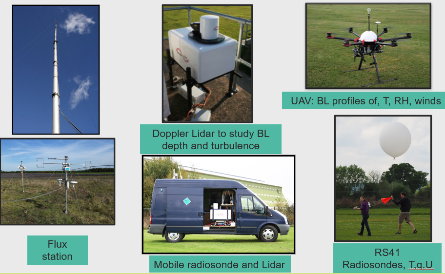
Ground based observations at supersite
- Doppler lidar
- Radiosonde station
- Surface flux station with 16m tower
- Microwave radiometer
- Soil temperature and moisture
- Components of surface energy balance
- Aerosol size distribution (accumulation and coarse modes)
- Cloud radar (TBD)
- UAV observations.
Additional ground-based activities
- Radiosonde facility in van — mobile
- Additional Doppler lidars at Chilbolton and Cardington – spatial variability in BL growth and turbulent development
- Up to 12 small automatic weather stations throughout WesCon region to track mesoscale features
- Up to two extra radiosonde sites within WesCon region – spatial variability of profiles

Figure 3. Example Met Office ground-based observation facilities.
Operational dual-pol radar network
- Research Radar at Wardon Hill
- Network spec. dual polarisation radar
- Can run custom scan sequence (PPI/RHI, faster/slower scans, LDR scans, …)
- 86 km from Chilbolton (Dean Hill radar is 20 km away)
 Figure 4. Example RHI radar scans.
Chilbolton radar
Plans to make limited use of the Chilbolton radar, in particular for retrievals of the 3d structure of convective clouds in synergy with aircraft observations and to provide better spatial distribution.
Modelling plans
We will use the observational dataset from WesCon to help develop next generation modelling capabilities including:
- Understanding the representation of convection in Urban-scale models (as part of our 5 year plan to develop and assess Urban-scale modelling capability).
- Scale aware parameterisations for convection and turbulence for use in km scale and Urban-scale models including the convection parameterisation, CoMorph and TKE turbulence schemes.
- Other relevant parameterisations such as CASIM (Cloud Aerosol Interaction Microphysics).
- Interactions of large scale and small scale model errors using an ensemble approach (particularly with regard to measurements of the pre-convective environment).
Summary
The WesCon project is in an advanced stage of planning for a field phase in summer 2023 but we are actively seeking opportunities for collaboration with external organisations who can provide extra observations/expertise which will complement the existing project.


