July so far, warm south east and cooler north west
Author: Press Office
14:37 (UTC+1) on Thu 20 Jul 2017
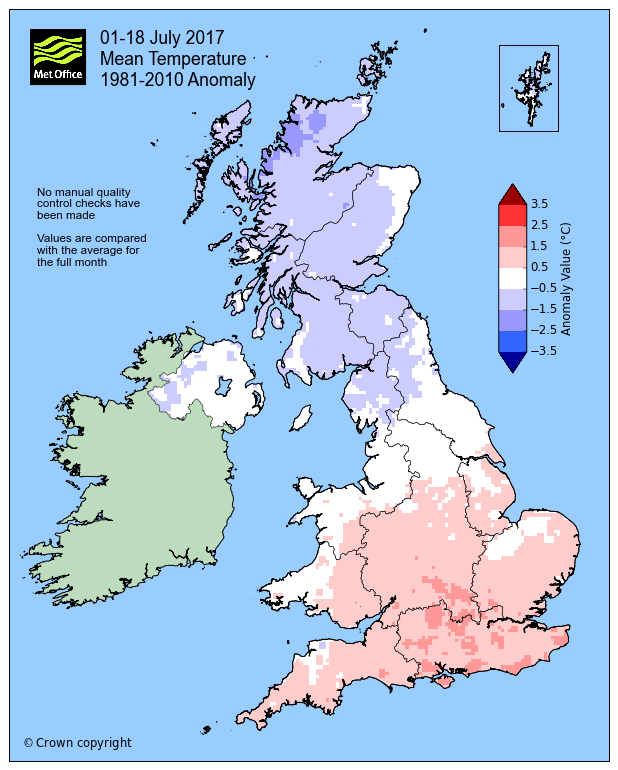
Provisional statistics for 1-18 July show that the UK has been split over the month so far, with the south east warmer than average and the north west cooler than average.
The south east and central southern England have so far had a warm month compared to the long term average, being 1.4 °C over the mean temperature for July. Conversely, the north of Scotland was 1 °C lower than its average.
Met Office climate scientist Dr Mark McCarthy, said: “The split can be explained by the presence of high pressure over the southern half of the UK for much of the month so far, allowing relatively stable conditions in this region. In the north west however, less protection was offered against low pressure systems that have led to wetter and cooler conditions in the north.”

Although the weather set up has meant temperatures have overall been lower in the north than average, there have been periods of fine weather. This can be seen in the sunshine hours statistics which show Northern Ireland and Scotland have already had 72 % and 67 % of their monthly sunshine respectively.
Despite recent thundery downpours in some parts of the UK, rainfall totals are fairly unremarkable for this point in the month across the UK, with most regions recording close to the average. The complexity of thundery weather systems mean that only very small areas will see the peak of intense rainfall, which will not always have an official rain gauge.
One example is the extremely localised flooding in Coverack in Cornwall. The very far eastern edge of the Lizard peninsular experienced intense rainfall and hail however just half a mile away it remained dry. Reports from a voluntary observer in nearby St Keverne showed 105 mm of rain had fallen and this will be verified in due course.
|
1-18 July provisional figures |
Mean temp (°C) |
Rainfall (mm) |
Sunshine (hours) |
|||
|
Actual |
Diff from avg (°C) |
Actual |
% of avg |
Actual |
% of avg |
|
|
UK |
15.2 |
0.1 |
37.9 |
48 |
113 |
66 |
|
England |
16.9 |
0.7 |
30.2 |
48 |
125 |
65 |
|
Wales |
15.6 |
0.5 |
30.4 |
33 |
118 |
66 |
|
Scotland |
12.4 |
-0.8 |
50.9 |
51 |
94 |
67 |
|
N Ireland |
14.3 |
-0.3 |
47.7 |
59 |
102 |
72 |
Looking ahead to the main holiday season, the weather stays pretty changeable with low pressure controlling our weather for the next few days. We can expect unusually wet and windy weather for some areas on Friday and a mixture of sunshine and showers in many places throughout the weekend, the best of the weather being reserved for northwest Scotland. Things do look slightly better as we head into the start of next week, although that may only be for a short while.
If you are planning a journey it's always good to plan ahead, Highways England Chief Executive, Jim O’Sullivan, said: "I want all drivers to arrive at their destinations safely during the summer holidays. We are urging motorists to make sure they are ready to go on their journeys by checking their fuel, tyres and oil. With a few simple checks everyone will be safer."
You can keep up to date with the weather using our forecast pages, on our popular mobile app which is available for iPhone from the App store and for Android from the Google Play store and by following us on Twitter and Facebook, as well as using.


