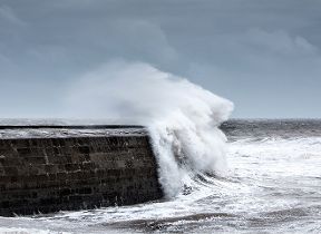
Wet and windy weekend follows Storm Eunice
Author: Press Office
21:18 (UTC) on Fri 18 Feb 2022
Following Storm Eunice’s departure out to the east late on Friday night, an unsettled weekend of weather is to come for many.
Yellow warnings have been issued through Saturday and Sunday, highlighting the ongoing risk of wind and rain, although much less impactful than Storm Eunice.
Met Office Chief Meteorologist Steve Ramsdale said: “Winds will decrease from their exceptionally high levels on Friday, but there’s a continued wet and windy theme for many through the weekend.
“The south will see wet and windy conditions on Saturday, before areas to the north and west, including Northern Ireland, see some more potentially disruptive conditions on Sunday. Weather warnings have been issued but should be checked throughout the weekend for any ongoing updates.”
Saturday’s yellow warning for wind covers much of the southwest, southern Wales and coastal areas in the south of England, where gusts of around 60mph are possible on the coasts, and around 40-50mph further inland. This will be accompanied by some persistent rain for many in the south, which will move eastwards as the day progresses.
⚠️ Yellow weather warning issued ⚠️
— Met Office (@metoffice) February 19, 2022
Snow across parts of northern England
Saturday 1100 – 1500
Latest info 👉 https://t.co/QwDLMfRBfs pic.twitter.com/n6yYQ1CZ3H
Much of Scotland will enjoy a fine day on Saturday, although further rain will affect England and Wales with perhaps some snow across parts of the Midlands and southern Pennines.
However, wind and rain will be the main theme of Sunday for many, with Yellow Weather Warnings issued.
RAC Breakdown Spokesman Rod Dennis said: “Drivers will be glad to see the back of Storm Eunice but it looks like it will have a sting in its tail with conditions on the roads remaining challenging right through the weekend. With winds still strong and gusty, it’s important drivers don’t take any chances, so we urge them to slow down and leave plenty of space between themselves and the vehicle in front.
“It’s not just strong winds that they’ll need to contend with – roads will turn slippery in the north on Saturday, while on Sunday intense rainfall becomes a feature making driving arduous. If conditions get particularly bad again, people should consider postponing their journeys, and for those who have to drive, it’s vital they keep their wits about them at all times.”
Storm Eunice
Storm Eunice brought significant disruption to many on Friday as it moved eastwards across the UK.
Needles on the Isle of Wight has provisionally broken the England national record for a one-off wind gust recorded, with 122mph. However, this weather station is particularly exposed to the elements and is not representative of much of the wind seen elsewhere in the UK, where the highest gusts have generally been between 80 and 90mph.
#StormEunice has brought extremely strong winds across many parts of the UK
— Met Office (@metoffice) February 18, 2022
Here's a provisional roundup of the highest gusts recorded during the day as Eunice passed through ⬇️ pic.twitter.com/gSr1VRhGIr
People are advised to check their local resilience authorities for ongoing safety advice around travel and preparations.
For more information on how to prepare for severe weather, please visit our WeatherReady advice.
Check the latest forecast for your area on our website, by following us on Twitter and Facebook, as well as on our mobile app which is available for iPhone from the App store and for Android from the Google Play store. Keep track of current weather warnings on the weather warning page.


