Unsettled weekend ahead of Christmas
Author: Press Office
11:36 (UTC) on Thu 19 Dec 2024
The weather is turning more changeable for the end of this week and weekend with some wet and very windy weather for many.
A deep area of low pressure will cross the far north of the UK on Saturday bringing rain and disruptive strong winds across large swathes of the UK. National Severe Weather Warnings for wind have been issued for both Saturday and Sunday highlighting the chance of disruption.
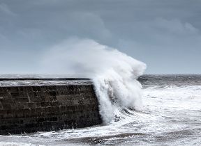
An unsettled and very windy weekend is on the way with a brief cold snap on Sunday 🌬️
— Met Office (@metoffice) December 19, 2024
Find out if the weather will feel festive in the run-up to Christmas or if the wet and windy weather will return 🎄👇 pic.twitter.com/QAcG1CajGZ
Met Office Deputy Chief Meteorologist, Rebekah Hicks, said: “This period of disruptive weather coincides with a busy period on UK roads as the festive getaway starts for many.
The area of low pressure will bring rain and strong winds on Saturday, with a chance of significant disruption especially to transport networks across the north, including the potential for ferry cancellations. The strongest winds are expected across northern Scotland on Saturday afternoon and evening, with the potential for gusts of 80 to 85 mph in coastal districts. The strong winds will be more widespread on Sunday with gusts of 50-60 mph across much of northern, central and western UK, locally higher for coasts and across high ground.”
Douglas Cairns from Transport Scotland said: “The strong winds across Scotland this weekend are expected to have an impact on the transport network. Road, rail, air and ferry services are all likely to be affected by the conditions, with longer journey times and cancellations possible, as well as potential restrictions on bridges. The network is also expected to be busier than usual, given it’s the last weekend before Christmas.
As always, we ask travellers to plan their journeys before setting off to ensure they reach their festive celebrations in good time. If you’re driving, make sure your vehicle is winter ready and follow any Police Scotland travel advice that may be in place. Traffic Scotland provides up-to-date travel information on the trunk road network through its website, X account and internet radio broadcasts.
“The same advice goes for other modes of transport – if you are planning to travel by rail, air or ferry, stay in contact with your operator for the latest service information.”
Turning more settled from Christmas Day
The winds will ease for the start of next week but there will be further rain or drizzle moving east across the UK on Monday night. Christmas Eve will be a mild, blustery day with further rain or drizzle at times in the west and the best chance of sunny spells in the east.
Christmas Day itself is likely to be settled, mostly cloudy and dry, although strong winds and spells of rain are likely in the far north. Temperatures are expected to be widely very mild, with the chance of settling snow looking slim.
We’ll be giving more details as we get closer to the day, so do keep up-to-date with the latest Met Office forecast.
Find out more about the Met Office definition of a ‘white Christmas’.
Where to get your Met Office weather forecast
You can find the latest forecast on our website, on YouTube, by following us on X and Facebook, as well as on our mobile app which is available for iPhone from the App store and for Android from the Google Play store.