It’s now 20 years since a devastating flood swept through the small Cornish village of Boscastle. A month’s worth of rain fell in just two hours, causing two rivers to burst their banks and about two billion litres of water to rush straight into the village. Whilst rainfall was in the forecast that day, the intensity of that rainfall and its impact on the village was not predicted, meaning residents had little time to react.
But would things be different if this happened today? The Met Office’s Professor Brian Golding says we would be ‘much better prepared today’ than we were in 2004.
Why did it happen?
On the 16 August 2004, an upper trough associated with an area of low pressure to the southwest of the UK led to intense thunderstorms developing along a stationary sea-breeze front over the moors to the east of Boscastle, which saw more than 200mm of rain fall in just five hours.
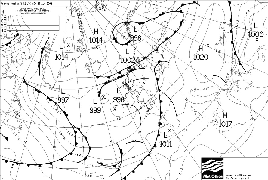
Synoptic chart for midday 16 August 2004
What were the impacts?
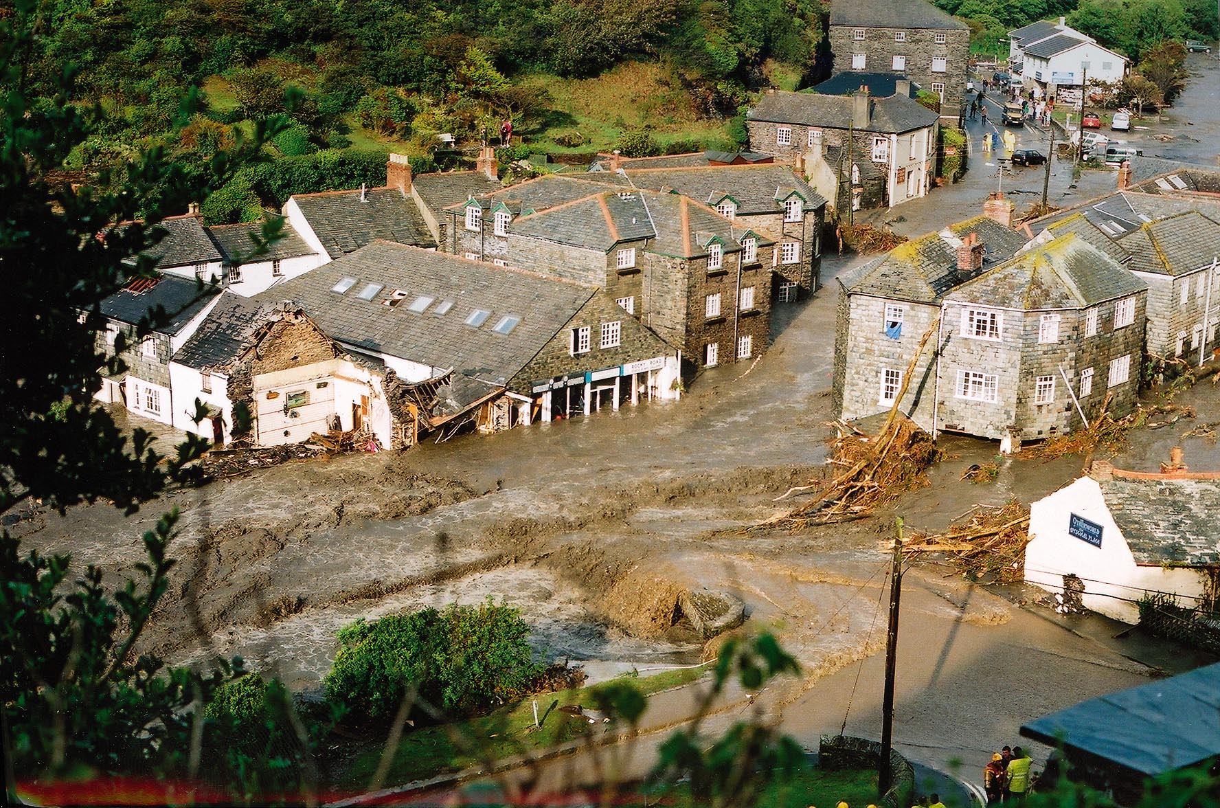
Many properties were destroyed, the church was filled with six feet of mud and water, cars, walls and bridges were swept away. A massive helicopter aided rescue operation was launched by HM Coastguard and the military, which saw residents being airlifted from trees and rooftops. Thankfully there were no fatalities.
Read more about the Boscastle event.
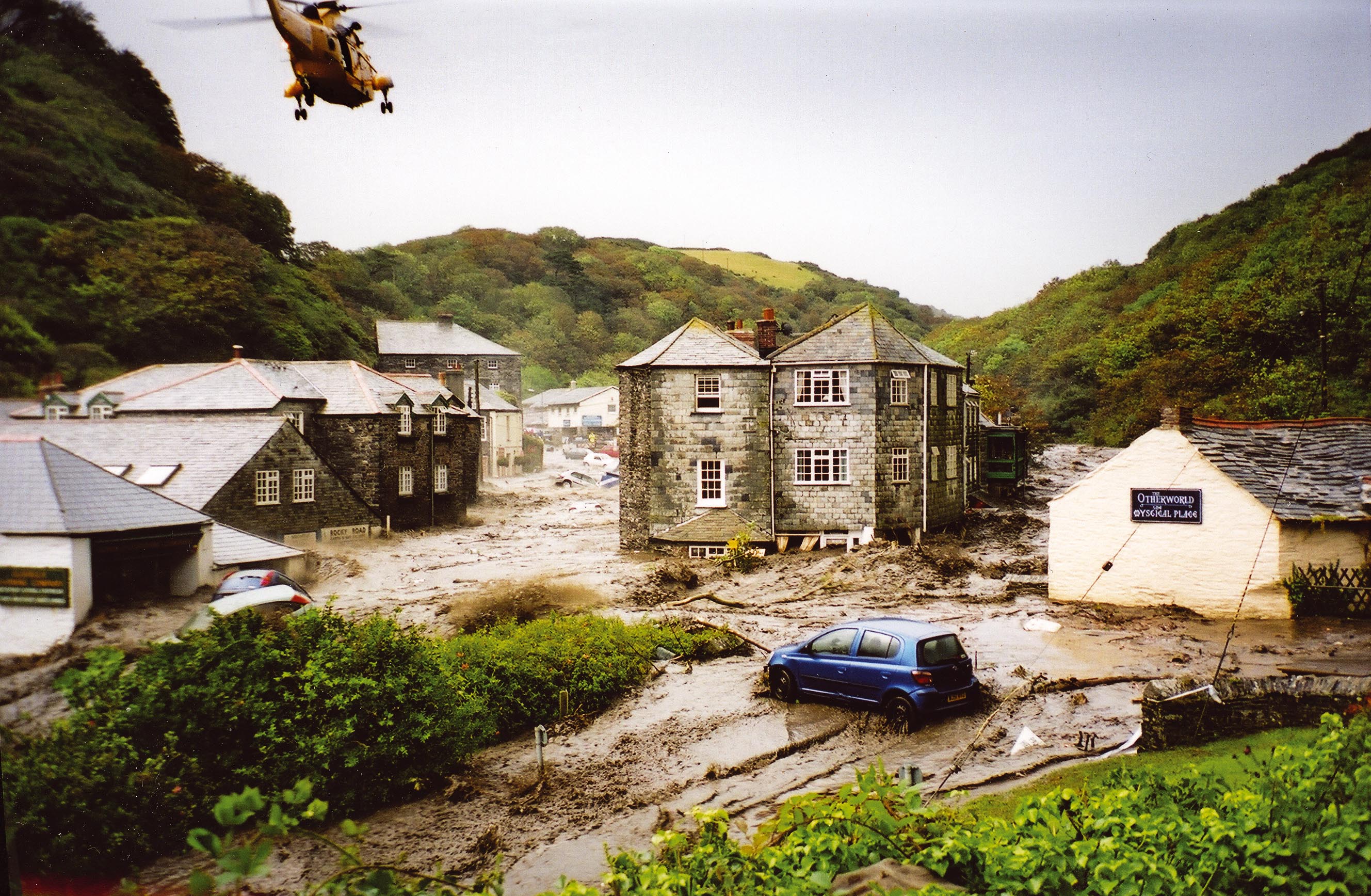
Picture from The Environment Agency
What if it happened now?
We have seen many advancements in meteorological understanding, forecasting capabilities and working practices since 2004, which have improved the way that severe weather and its impacts are forecast and subsequently managed.
Improved forecasting capabilities
We’ve made significant improvements in our forecasting capability, with better predictions of the conditions that lead to such downpours and much more precise model data, enhancing our ability to predict and respond to extreme weather events.
- Higher resolution models
Back in 2004, the operational forecast model had a resolution of 12 km. This means the grid squares on the model measure 12km by 12km. As you can see from the radar image on the left, these large grid squares were able to point out a weak signal of light rain across most of the Southwest Peninsula, but they weren’t able to capture such a small-scale line of thunderstorms and thus, forecasters could not predict just how intense they were going to be on such a small area.
Today though, our operational models are much more detailed. As seen on the right, higher resolution models (1km by 1km) are able to show the line of thunderstorms with much more accuracy and detail.
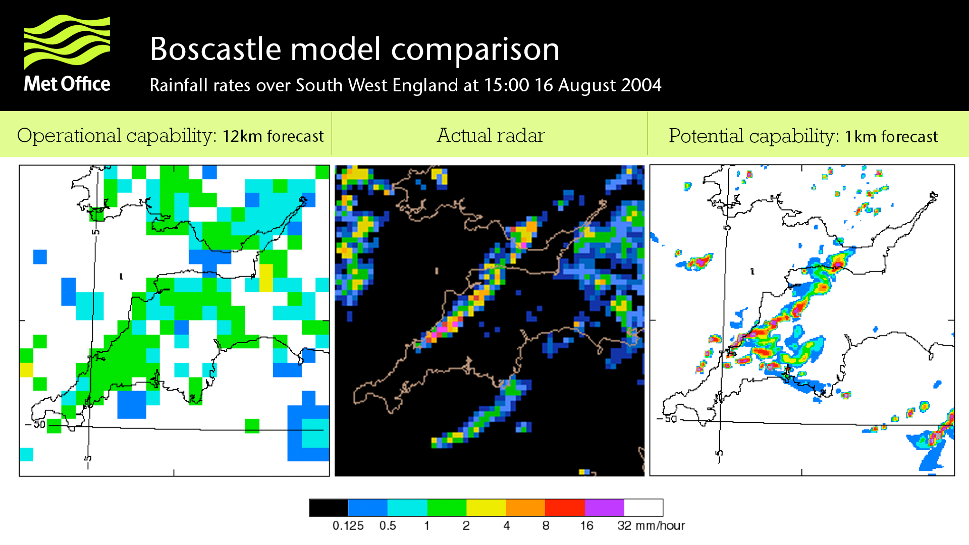
Met Office meteorologist Alex Burkill explains: “If Boscastle were to happen today and we used our current high-resolution forecast, you can see that it much better captures the intense rain that lingered parallel to the north Cornwall coast.
“You can see that the model shows the development of thunderstorms with much more representative intensity and location, which was very similar to the radar data from the actual time as shown in the middle.
“Had we had higher-resolution models back in 2004, we would have been able to pick out such a small-scale extreme weather event with a longer lead time, allowing us to provide advance warning and advice.”
Find out more about forecast models.
- A move to ensemble forecasting
A further improvement to our forecasting has been the move to what’s called ‘ensemble’ forecasting. This is where instead of running just a single forecast, the computer model is run a number of times from slightly different starting conditions. The complete set of forecasts is referred to as the ‘ensemble’, and gives the forecaster a much better idea of how the weather might develop.
In the case of Boscastle, if ensemble forecasting had been an option, forecasters would have been able to compare differing forecasts and therefore be able assess their likelihood, warning communities of the risk of extreme weather.
Find out more about ensemble forecasting.
- Website and app improvements
Although our website was operational in 2004, our forecast app was not launched until much later in 2016. Since then, we have made many improvements to the forecasts we provide, giving more precise and up-to-date weather information, including severe weather warnings straight to people’s mobiles.
We’ve recently undertaken a significant upgrade to the data system that generates our seven-day forecasts throughout the UK and around the world for example.
- New nowcasting tools
Another, more recent initiative is a technique known as ‘nowcasting’. Nowcasts are short-range observations-based forecasts valid for periods of up to six hours.
Professor Brian Golding explains: “The nowcasting initiative has produced several tools that support early (one hour ahead) recognition of the potential for extreme local rainfall. So, if we had a team working on nowcasting at the time of Boscastle, we’d have been able to quickly produce detailed guidance on the location, extent and timing of the imminent, high impact weather. This sort of information is critical for emergency responders as they work to protect lives and properties in local communities.”
Substantial flood management investment
Flood management has improved immensely since 2004, with the Environment Agency investing more than £10 million in improving flood defences in Boscastle.
Less visible, but incredibly important, was the opening of the Flood Forecasting Centre (FFC) in 2009 following recommendations made in the Pitt Review.
A partnership between the Met Office and the Environment Agency, the FFC combines meteorology and hydrology expertise to forecast for river, tidal and coastal flooding, as well as flash flooding from extreme rainfall. The team is operational 24/7 and plays a key role in the provision of earlier and more accurate warnings of flood risk, supporting Government, local resilience communities and category 1 and 2 responders to keep the public safe.
Ben Johnstone, Environment Agency Flood and Coastal Risk Manager for Devon, Cornwall and Isles of Scilly, said: “Building on the lessons learned from Boscastle, our close work with the Met Office has led to significant advancements in flood monitoring, forecasting and warning services. The opening of the Flood Forecasting Centre has been fundamental to our collaboration, allowing us to predict extreme weather with greater accuracy, issue more precise and timely flood warnings and respond more swiftly and effectively when needed. We will continue this close partnership, to keep innovating to help communities become more flood resilient.
“We can never eliminate flooding entirely and, due to our changing climate, we can expect more intense rainfall all year round. We encourage everyone to sign up for free flood warnings as a vital way of staying informed and protecting yourself and loved ones.”
Picture from The Environment Agency
Changes in the way severe weather is communicated
Our National Severe Weather Warning Service – which warns of potential impacts caused by severe weather – has been updated and is now based on a combination of the level of impacts the weather may cause, and the likelihood of those impacts occurring. The warnings now give the public and emergency responders more focused and useable advice, helping them prepare or take action earlier.
The Met Office continues to invest in new ways of predicting heavy rainfall events on a small scale to produce better warnings.
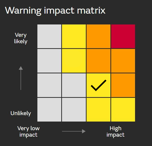
Our National Severe Weather Warning Service matrix
On the ground, we have set up a network of Met Office Advisors (Civil Contingencies) who ensure that local resilience teams are aware of the development of potentially severe weather and what the impacts might be so that they can plan and prepare.
A huge change in the past two decades, has been in communications. 20 years ago, people mainly got their weather forecasts through the radio and television. If they missed the forecast in the morning, it’s quite likely they wouldn’t hear another until lunchtime or the evening. But today, we are constantly in communication, and we can reach people far more easily.
If we need to communicate extreme weather, we can reach our 2.4 million followers on social media in an instant. Warnings would be seen by the 6.3 million people who have the Met Office App and on an extreme weather day, our public website and mobile apps see 20.6 million page views and 2.1 terabytes of data downloaded.
The next 20 years
As we saw in the dramatic European floods of 2021 where more than 200 people were killed, extreme convective rainfall can still catch us out, even if well forecast days in advance.
With higher maximum daily temperatures and more intense rainfall affecting the UK because of climate change, the impacts of flooding are likely to be greater in the coming decades. Ongoing research and technology development are therefore crucial.
Our new supercomputer will ultimately be six times more powerful than the current machine, enabling further developments in ground-breaking weather and climate change modelling.
Artificial Intelligence (AI) is also opening-up new ways to forecast better. Last year, we announced a ground breaking partnership with the Turing Institute to develop AI models for improved forecasting. Chief Meteorologist Steve Ramsdale explains:
“For high impact weather events such as Boscastle, AI could be utilised at multiple forecast timescales, such as recognising the potential for severe weather at longer lead times up to very short term, highly localised nowcasts, combining traditional and novel observational datasets with high powered numerical weather prediction models.
“The challenge now is bringing together these diverse datasets in an effective and interpretable manner whilst maintaining human intuition and insight into, along with oversight of, the resulting output ensuring accurate and trustworthy information flows out of the Met Office, fulfilling our core purpose of helping us all make better decisions to stay safe and thrive.”
And this is just the tip of the iceberg for the future of this transformative technology. Our scientists are involved in pioneering research, such as this new study led by the Met Office, which uses machine learning to improve hyper-local forecasts for heatwaves in urban areas.
Professor Simon Vosper, Executive Director of Science at the Met Office, said: “Our forecasting capabilities are constantly developing and improving thanks to world leading, cutting-edge science and technology and although the conditions that led to the Bocastle floods will undoubtedly happen again, we are much better prepared two decades on.
“We have earned a reputation for continually pushing the boundaries of scientific, technological and operational expertise, and we will continue to do so, so that we can meet the demands of today and the future.”
