Briefing on Arctic and Antarctic sea ice - July 2020
Alex West and Ed Blockley
Summary
- Arctic sea ice extent is currently the lowest on record for the time of year, following the fastest two-week rate of ice loss on record.
- The record low extent was driven by rapid ice loss in the seas north of Siberia, associated with southerly winds and very mild conditions during June; the same weather pattern caused a notable heatwave in Siberia, with a provisional record high temperature of 38°C in the Siberian town of Verkhoyansk.
- Although predictions submitted to the Sea Ice Prediction Network in June do not suggest a heightened chance of a new record of minimum ice extent, these were compiled before the recent rapid ice loss and do not take account of this information. It is likely that the predictions compiled in July will be somewhat lower.
- A statistical prediction of September extent using the most recent data suggests there is a small chance of setting a new record minimum extent, and a higher than 50% chance of 2020 recording at least the second lowest September extent.
- At this point in the melt season uncertainty remains high, and September extent is still very dependent on weather during the remainder of the summer.
- Antarctic sea ice extent is currently 12th lowest on record for the time of year, but significantly higher than the same date last year, when it was third lowest on record.
Current Arctic sea ice extent
Arctic sea ice extent on 11th July was 7.82 million sq km. This was the lowest extent for this date on record, the next lowest having been 7.97 million sq km (recorded in 2019). It was 2.11 million sq km below the 1981-2010 average (Figure 1).
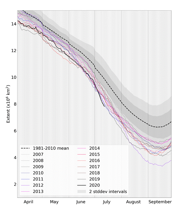
Figure 1. Daily Arctic sea ice extent for 2020, compared with recent years and the 1981-2010 average with ± 1 and 2 standard deviation intervals indicated by the shaded areas. Data are from the National Snow and Ice Data Center (NSIDC).
Extent was exceptionally low in the Laptev Sea, which saw very fast ice retreat during the month of June due to very mild weather in this region (discussed below). Extent was also very low in the Kara Sea and East Siberian Sea, and was slightly below average in the Chukchi and Beaufort Seas (Figure 2).
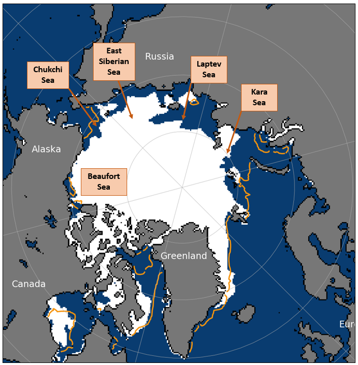
Figure 2. Arctic sea ice extent on 11th July 2020, with 1981-2010 average extent indicated in orange, and the regions referred to in the text labelled. Underlying map and data courtesy of NSIDC.
June 2020 in context
Average sea ice extent for June 2020 was 10.82 million sq km, according to the HadISST1.2 dataset (Rayner et al, 2003). This was 1.05 million sq km below the 1981-2010 average and was the third-lowest June sea ice extent in the satellite record (since 1979). However, it was only 0.02 million sq km below the long-term linear trend (Figure 3).
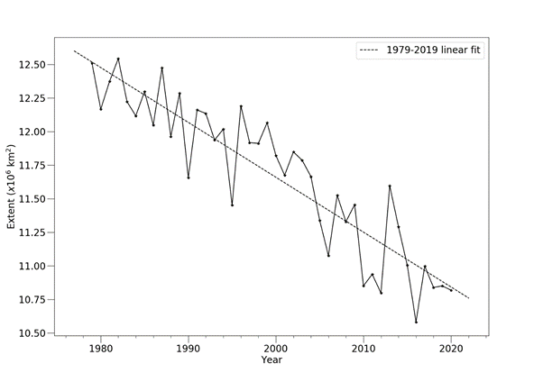
Figure 3. Average June Arctic sea ice extent according to the Hadley Centre Sea Ice and Sea Surface Temperature (HadISST) 1.2 dataset (Rayner et al, 2003).
The average rate of sea ice loss in June was 72,000 sq km per day. This was 13,000 sq km per day faster than the 1981-2010 average, and the 12th fastest rate of June sea ice loss in the satellite record. The rate of ice loss increased abruptly at the end of the month, and the period 27th June – 10th July saw the highest 2-week rate of ice loss in the satellite record.
June 2020 was another unsettled, stormy month over most of the Arctic Ocean (Figure 4a), with near-average upper air temperatures across most of the Arctic Ocean (Figure 4b). However, a ridge of high pressure extended from Eastern Siberia over the Chukchi and Beaufort Seas; to the west of this ridge, persistent southerly winds over the Laptev Sea drove very mild air over the sea ice, explaining the rapid retreat of ice in this region. The same weather pattern caused a provisional record high temperature of 38C in the Siberian town of Verkhoyansk, previously known as the location of the coldest recorded temperature in the Northern Hemisphere. Continued southerly winds into the start of July saw ice in the East Siberian Sea retreat rapidly also, resulting in the current record-low sea ice extent.
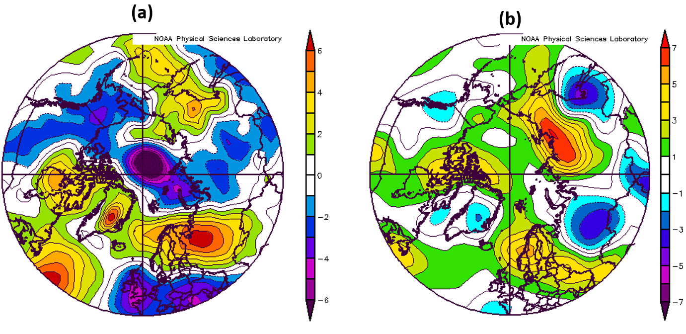
Figure 4. (a) Mean sea level pressure anomaly (hPa); (b) air temperature anomaly (°C) at 925 hPa, for June 2020. Anomalies are relative to the 1981-2010 average. Data are from the NCEP reanalysis (Kalnay et al, 1996).
Outlook for September
There are a variety of means by which September average sea ice extent can be predicted at this point in the melt season. Some of these are displayed in Figure 5, and described below:
- The Sea Ice Prediction Network (SIPN) July Outlook report comprises 33 predictions of 2020 September average sea ice extent from scientific centres around the world. The median prediction is 4.33 million sq km, with an interquartile range of 4.06 to 4.59 million sq km. Only two predictions fall below the record low September extent of 3.60 million sq km.
- A statistical prediction based on extrapolating the long-term linear trend gives a September sea ice extent of 4.27 ± 1.06 million sq km.
- There is a reasonable correlation between mean September ice extent and the extent for 27th June – 11th July (the most recent 15 days of data available at the time of writing). Applying simple statistical methods to the anomalies for these dates gives a prediction of September mean extent of 4.18 ± 0.81 million square km, indicated in blue on Figure 5.
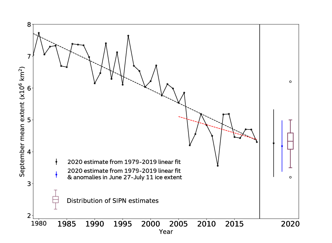
Figure 5. September median Arctic sea ice extent since satellite records began in 1979 from the HadISST1.2 dataset (Rayner et al., 2003), with SIPN Sea Ice Outlook and statistical predictions for September 2019. For the statistical predictions, error bars represent twice the standard deviation of September mean ice extent about the trend lines with respect to which the estimates are taken. The Sea Ice Outlook is shown as a boxplot indicating range, median and quartiles of the 33 predictions submitted. Values more than 1.5 interquartile ranges from the first and third quartiles are shown as outliers.
Looking at the statistical prediction in more detail, the central prediction of 4.18 would, if verified, represent the second-lowest September extent on record, narrowly ahead of 4.20 in 2007. The lower bound of the prediction, 3.37 million sq km, would if verified represent a record low September ice extent, comfortably ahead of 3.56 in 2012.
The predictions compiled for the SIPN report in June do not yet show a heightened probability of a record minimum September extent being recorded in 2020. However, these predictions do not take account of the rapid sea ice loss observed in late June and early July; the predictions compiled for the July report are likely to be somewhat lower. Melt rates between now and September will be highly dependent on Arctic weather patterns over the remainder of the summer. For example, one factor causing uncertainty is likely to be whether the blocking high pressure system observed over East Siberia during late June and early July persists for many more weeks, or whether circulation in the region becomes more zonal. Zonal circulation describes weather in which the wind direction is from east or west, and tends to imply less exchange of warm air with midlatitudes.
Current Antarctic sea ice extent
Antarctic sea ice extent on 11th July was 15.34 million sq km. This was 0.23 million sq km below the 1981-2010 average, and was the 12th lowest extent on record for this date, the lowest having been 14.66 million sq km in 1986 (Figure 6).
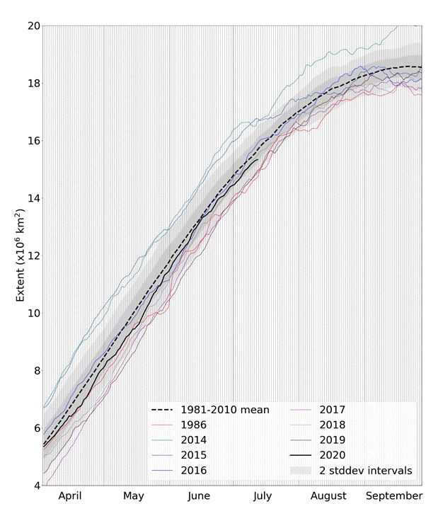
Figure 6. Daily Antarctic sea ice extent for 2020, compared with recent years, the low ice year of 1986, and the 1981-2010 average, with ± 1 and 2 standard deviation intervals indicated by the shaded areas. Data are from NSIDC.
Extent was very low in the Bellingshausen Sea, but this was countered by higher than average extent in other parts of the Southern Ocean, for example the eastern Ross Sea and the Weddell Sea (Figure 7).
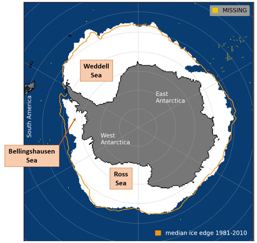
Figure 7. Antarctic sea ice extent on 11th July 2020, with 1981-2010 average extent indicated in orange, and regions referred to in the text labelled. Underlying map and data courtesy of NSIDC.
References
Kalnay, E., and Coauthors, 1996: The NCEP/NCAR 40-Year Reanalysis Project. Bull. Amer. Meteor. Soc., 77, 437–472, https://doi.org/10.1175/1520-0477(1996)077<0437:TNYRP>2.0.CO;2.
Rayner, N. A.; Parker, D. E.; Horton, E. B.; Folland, C. K.; Alexander, L. V.; Rowell, D. P.; Kent, E. C. and Kaplan, A.: Global analyses of sea surface temperature, sea ice, and night marine air temperature since the late nineteenth century. J. Geophys. Res. Vol. 108, No. D14, 4407 10.1029/2002JD002670, 2003.


