
Satellite image of the month - 2022
Showcasing some of the Met Office's satellite imagery from around the world showing weather in action, new views of the world and extra commentary on how we collect and create the images from our Space Applications team.
December 2022 - solar prominence eruptions
8 December 2022
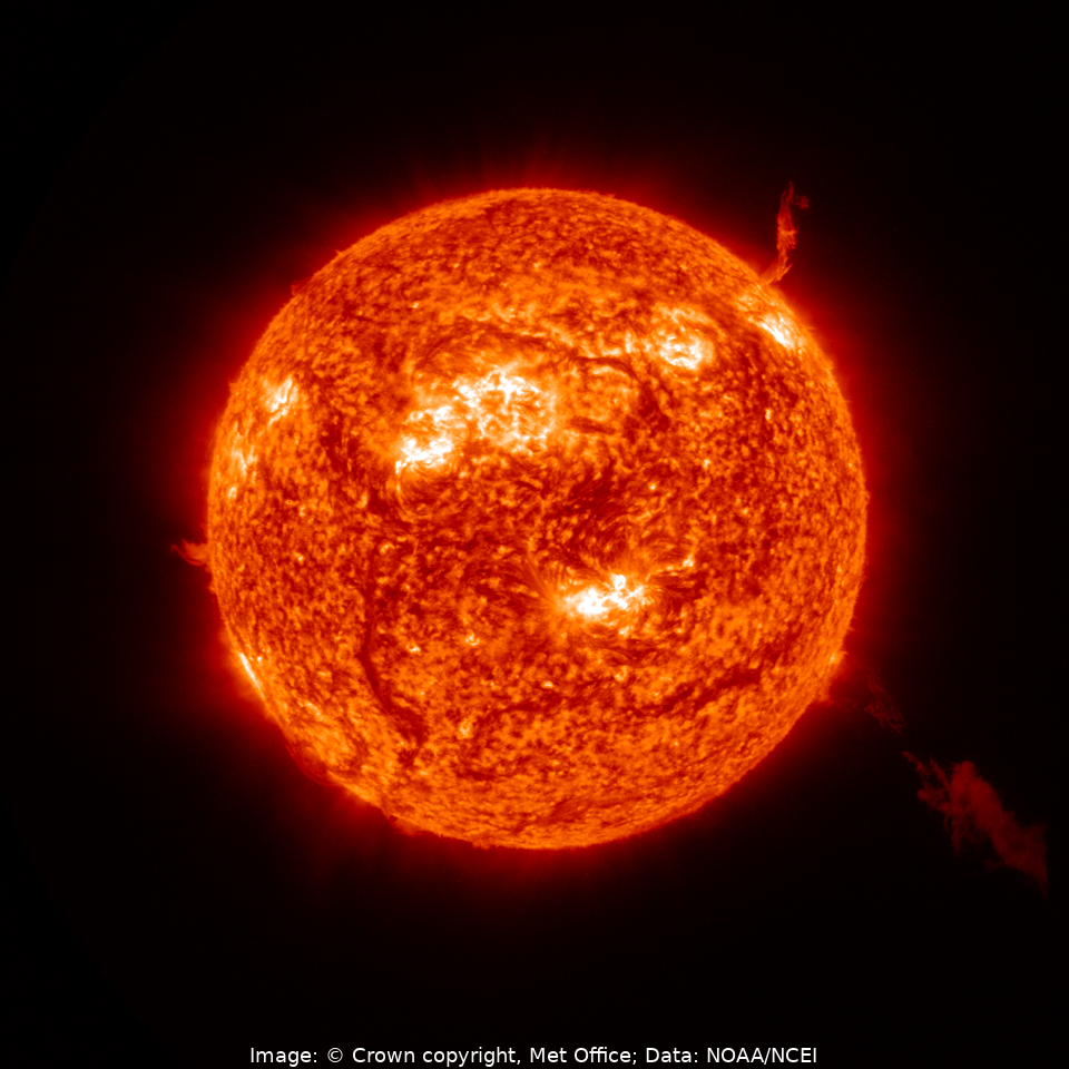
We finish off our 2022 satellite image highlights with a view not (as usual) of the Earth, but rather of the Sun. The image above is created using data from GOES-16's Solar Ultraviolet Imager (SUVI), a sophisticated extreme ultraviolet (EUV) telescope. This instrument allows us to monitor the Sun's very hot outer atmosphere (the corona), enabling us to see EUV photons that are created in the plasma of the corona but which are not visible from the ground due to absorption by the Earth's atmosphere. The image, taken on 8 December 2022, shows EUV radiation measured at a wavelength of 30.4 nanometres, with striking prominence eruptions being seen in the top-right hand and lower-right hand quadrants of the Sun's limb.
EUV photons, travelling at the speed of light, give valuable insights into the solar sources of space weather. SUVI observations help monitor unstable solar regions and warn of associated activity such as solar flares or coronal mass ejections, which can disrupt the Earth's ionosphere enough to impair terrestrial radio communications, and lead to power grid outages. They are therefore of key interest to forecasters of the impacts of space weather, at the Met Office and elsewhere.
Credits: Image: © Crown copyright, Met Office, Data: GOES-R Series Level 1b Solar Ultraviolet Imager (SUVI) Product in FITS Format, NOAA National Centers for Environmental Information
November 2022 - Mauna Loa eruption
28 November 2022
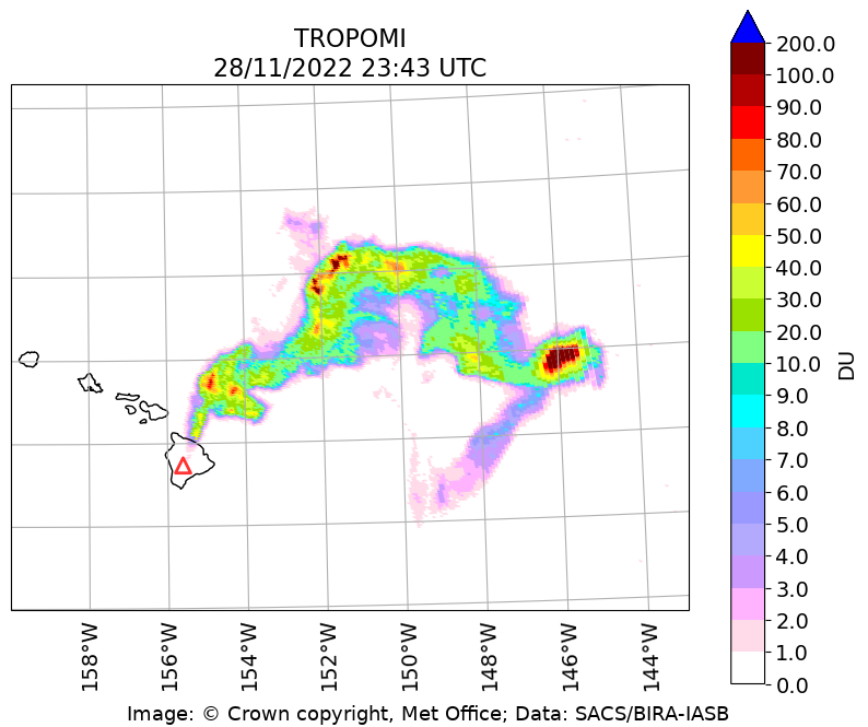
Mauna Loa, considered to be the world's largest active volcano, began erupting on 27 November 2022, the first time it had erupted since 1984. Little or no volcanic ash was injected into the atmosphere from this, but significant amounts of gaseous sulphur dioxide (SO2) were observed from the eruption over a period of around two weeks. The image above shows a well-defined plume of SO2 observed on 28 November 2022, derived from the TROPOMI instrument on the Copernicus Sentinel-5 Precursor satellite. This instrument can be used to infer a vertical column amout of SO2 in the atmosphere (measured in Dobson Units - DU) from measurements of solar radiation at several different ultraviolet wavelengths. In the image, the amount of SO2 present is colour-coded according to the scale on the right-hand side, and the location of the volcano itself is shown as a red triangle.
Credits: Image: © Crown copyright, Met Office, Data: SACS/Royal Belgian Institute for Space Aeronomy
November 2022 - lake-effect snow in North America
21 November 2022

Lake-effect snow is a phenomenon that often occurs in North America during autumn and winter, as cold air moves across the warmer open waters of the Great Lakes. The ensuing warming of the atmosphere at low levels causes de-stabilisation, producing rising air parcels. These in turn develop into narrow bands of convective cloud, oriented along the wind flow, that can rapidly deposit large amounts of snow downwind.
The above images show data from the VIIRS instrument on the NOAA-20 satellite, observed on 21 November 2022 after a period of intense lake-effect snowfall during the preceding days. The upper image is a true colour visible composite from an overpass at around 1820 UTC, which, because it reproduces closely what the human eye can see, shows deposited snow as white, the same colour as the clouds which are also present in this picture. The lower image shows a composite that makes use of some different near-infrared channels where the solar radiation is absorbed strongly by the lying snow, producing a characteristic red colour for this type of image. We see that large areas of land to the east of Lakes Michigan, Huron, Erie and Ontario have been affected by snowfall. Western New York State was particularly badly hit, with locations around Buffalo (marked) reporting over 80 inches (around 2 metres) of accumulated snowfall.
Credits: Images and Data: NASA Worldview Snapshots
October 2022 - simultaneous volcanic eruptions in the Kuril Islands
16 October 2022
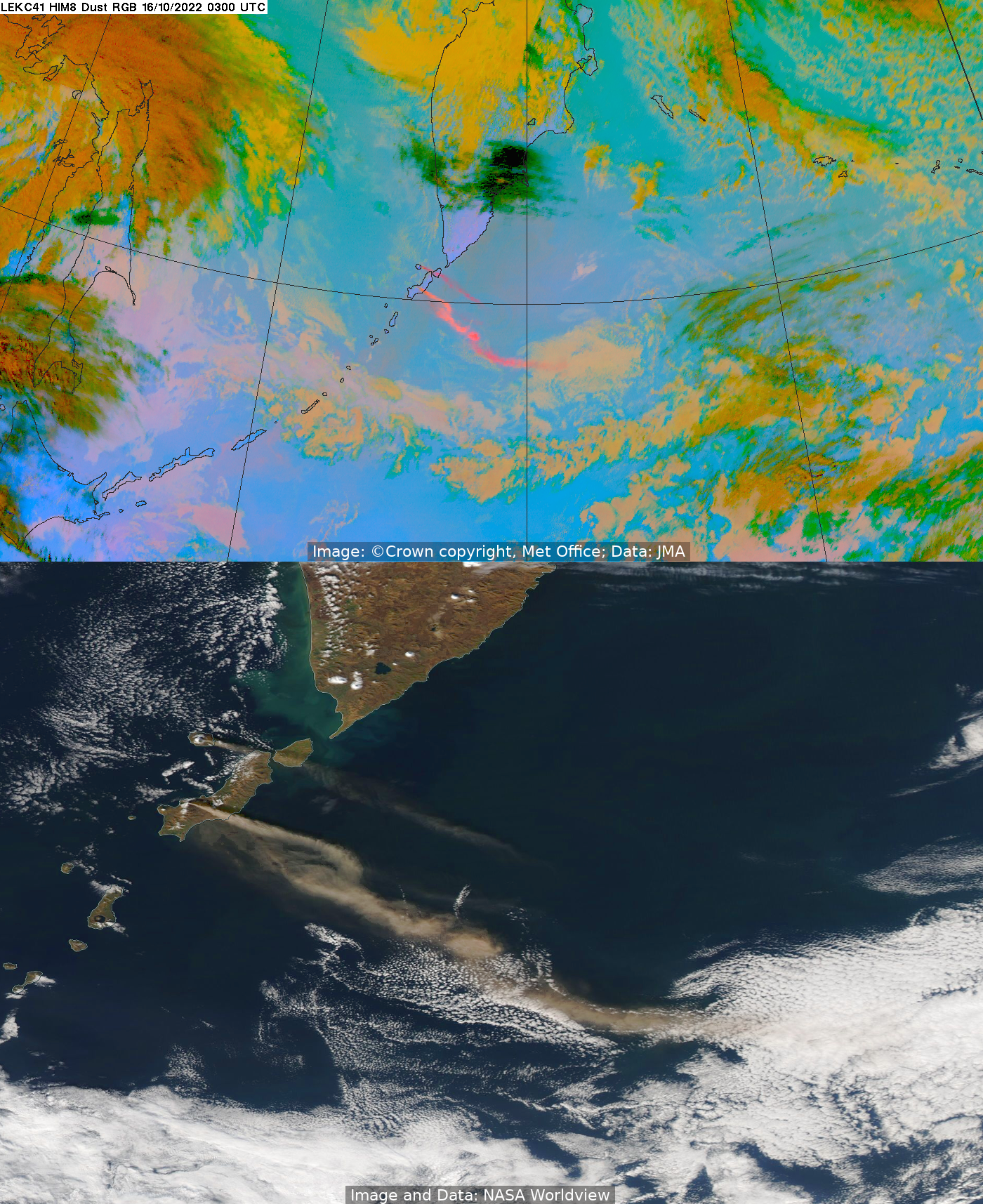
The images above show the unusual situation of two volcanoes, around only 60 km from each other, erupting at the same time. The images were captured at around 03:00 UTC on the 16th October 2022. The more northerly of the two erupting volcanoes is Alaid, the highest and northern-most volcano in the Kuril archipelago. The eruption seen just to the south of this is from the Chikurachki stratovolcano, which forms the highest peak on Paramushir, a larger island in the northern Kurils just south of the Kamchatka Peninsula.
The upper image is an infrared false-colour ("Dust RGB") composite, using data from JMA's geostationary Himawari-8 satellite, where the volcanic ash appears as bright orange/pink colours. The lower picture, taken from the MODIS instrument on NASA's polar-orbiting Aqua satellite, is a true colour visible image from an overpass at around the same time, with the ash showing as a sandy light brown colour.
Credits: Top - Image: © Crown copyright, Met Office, Data: JMA; Bottom - Image and Data: NASA Worldview
September 2022 - Severe storms over Italy
8 September 2022
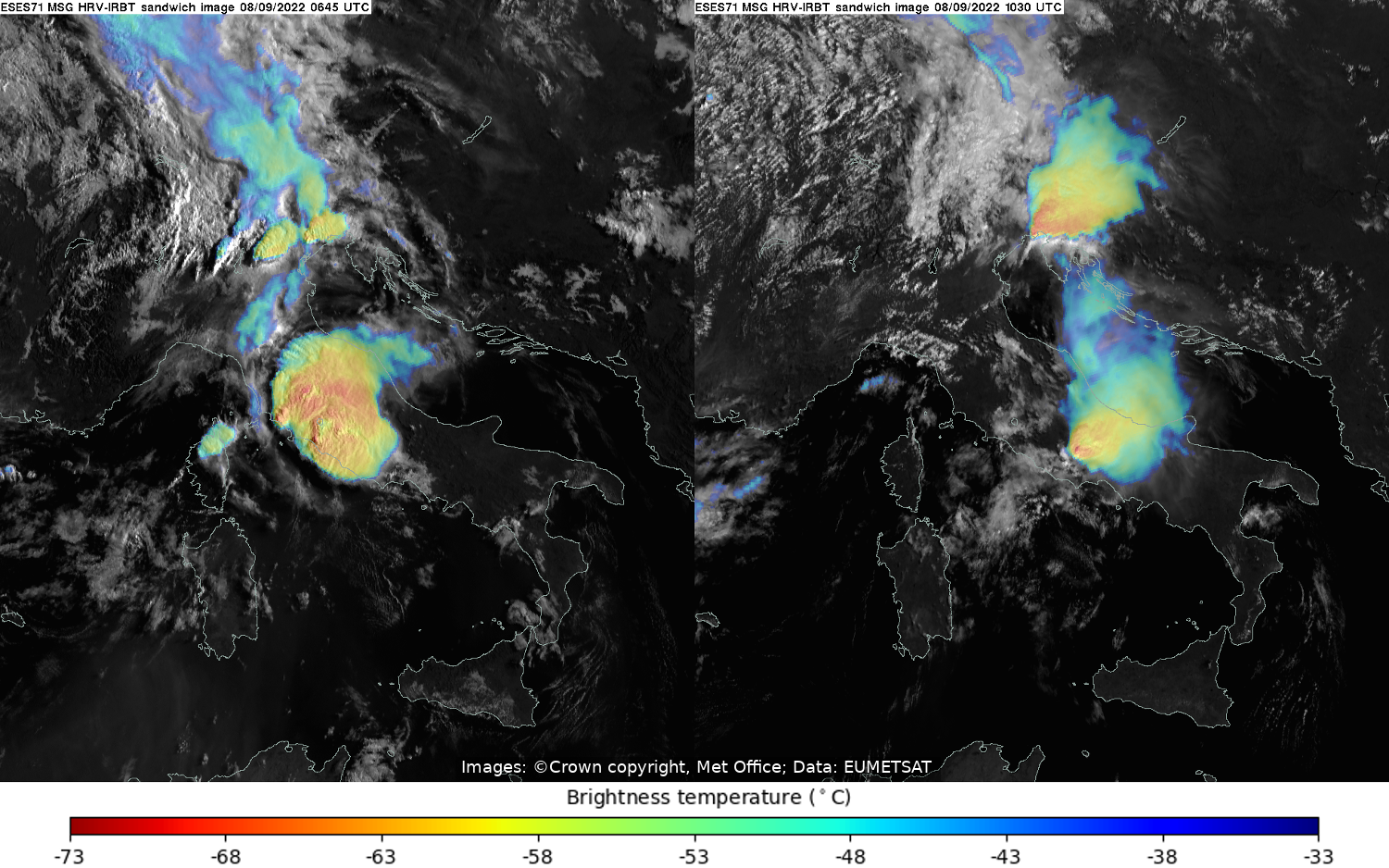
Severe storms caused disruption in many parts of Italy during September 2022, and the above images show some of the storms that developed in the early hours of 8 September and persisted for much of the day. In particular, the left-hand image from 0645 UTC shows a large mesoscale convective system (MCS) that developed over the warm waters of the Tyrrhenian Sea. This system was accompanied by strong winds, lightning, heavy precipitation, and reports of a tornado that hit the coastal city of Civitavecchia at around 07:30 UTC. Further north, two more developing storms can be seen, one to the east of Lake Garda (where a waterspout was reported that morning) and one to the north of Venice. The right-hand image shows the corresponding image from a few hours later. The MCS had moved eastwards during this time and its horizontal extent had decreased, althought the satellite image suggests that the storm activity was still severe in places. Meanwhile, one of the storms in the north is seen to have increased significantly in intensity as it moved across the Trieste area and into Slovenia.
The pictures above are examples of a so-called "sandwich" image, incorporating information from both visible and thermal infrared channels from the SEVIRI imaging instrument on board EUMETSAT's Meteosat-11 satellite. The signal from the thermal infrared channel (giving information on the temperature of the cloud tops) is colour coded (as per the legend beneath the image) and made to be transparent, and this is then overlaid onto a high-resolution visible image, so that the physical textures of the cloud-tops show through the coloured infrared temperature signal.
Credits: Images: © Crown copyright, Met Office, Data: EUMETSAT
August 2022 - Hot and dry weather over north-western Europe
10 August 2022
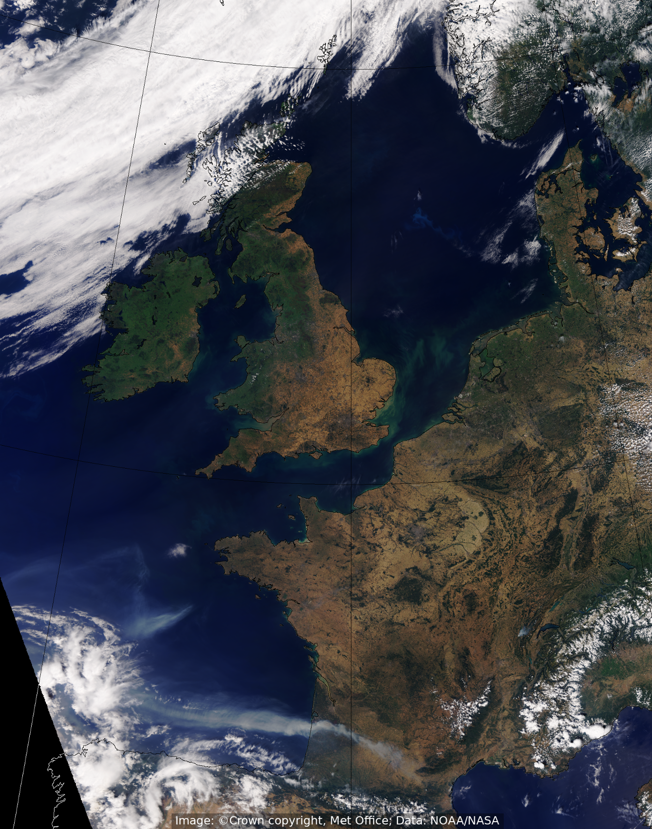
This image comes from the NOAA/NASA NOAA-20 satellite, showing a true-colour visible picture of the United Kingdom and western Europe at 1202 UTC on 10 August 2022 during a prolonged spell of hot and dry weather. High pressure was dominant over southern England and northern France, resulting in almost completely clear skies over the UK, with the exception of some cloud over north-west Scotland. France also is seen to be almost completely without cloud. Light winds were generally from the south-east over central and southern England, bringing in heat from continental Europe. Consequently, heatwave thresholds were exceeded in many parts of England and Wales on this day.
Looking further south over south-western France, one can see large plumes of smoke from ongoing severe fires in the Gironde area, which led to the evacuation of thousands of people from their homes and the destruction of thousands of hectares of forest.
Credits: Image: © Crown copyright, Met Office, Data: NOAA/NASA.
July 2022 - Phytoplankton blooms
6 July 2022
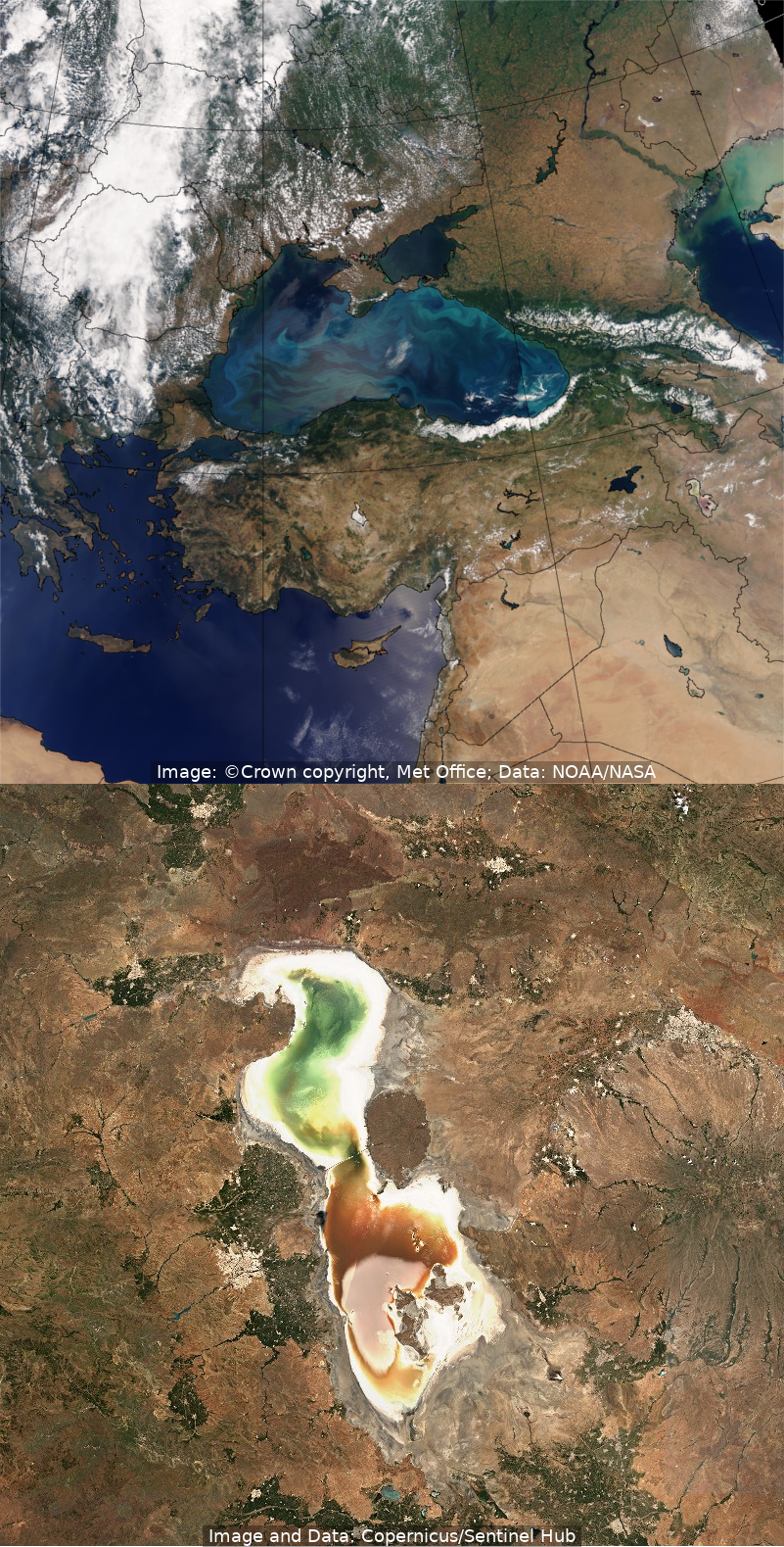
The top image shows large blooms of microscopic phytoplankton in the Black Sea on 6 July 2022. These blooms often occur at this time of year as sunlight levels increase, helping these microscopic marine algae to synthesise their own food via chlorophyll. The image comes from the NOAA/NASA Suomi-NPP satellite, a polar-orbiting satellite which collects data while circling the Earth passing over the north and south poles. One of the images we can create from the VIIRS instrument on this satellite is a true colour image, enabling us to see the land, sea and clouds from space as they would appear to the human eye.
In the same image, south east of the Black Sea and lying in the north-western corner of Iran (near the Turkish border), one can also make out Lake Urmia, a highly salty lake in which the water appears as both green and red. The lower image, taken from the Copernicus Sentinel-2 satellite at a similar time and using similar wavelengths, shows this lake in more detail. Here we can clearly see that the water in the lower portion of the lake is a striking red colour. Ongoing drought and an increased demand for irrigation water has led to a shrinking of the lake for several years, and this drying out has also increased the salinity. This in turn provides a prime breeding ground for a certain type of micro-algae which, in conditions of high salinity and light intensity, turns red due to the production of protective chemicals.
Credits: Top Image: © Crown copyright, Met Office, Data: NOAA/NASA. Bottom image: Copernicus Sentinel-2 data, processed by the Sentinel Hub.
June 2022 - Final image from Meteosat-8 received
1 June 2022
On 1st June 2022 we said farewell to Meteosat-8 after nearly 20 years of service. Although for many years situated over the Greenwich (0º longitude) meridian, the satellite has served the final years of its life offering geostationary weather data over the Indian Ocean Data Coverage region (centred at a longitude of 41.5º), which includes eastern Europe, the Middle East, and western Asia. Meteosat-8 will shortly be firing its thrusters for a final time, propelling it deeper into space to a graveyard orbit - this will minimise the risk to operational satellites if it breaks up. Meteosat-9 has already been moved to cover the Indian Ocean region in its place, albeit from a slightly different position.
Meteosat-8 was launched in 2002. It was the first satellite in the Meteosat Second Generation (MSG) series, providing a step change in capability that we’ll soon experience again with Meteosat Third Generation (MTG). Over its lifetime it has helped us gain insights into the behaviour of many types of severe weather, and also various environmental phenomena such as dust storms, volcanoes and other hazards to aviation and public safety. In addition Meteosat-8 has provided a long and reliable series of atmospheric motion vectors and infrared radiances for use in data assimilation in our Numerical Weather Prediction models.
The picture on the left above shows an image from the final Meteosat-8 data received at the Met Office, just before 0900 UTC on the 1st June 2022. The right hand image shows the equivalent view from Meteosat-9 just 15 minutes later, with the satellite (and hence the image) centred slightly further east at 45.5º longitude.
Credits: Images: © Crown copyright, Met Office, Data: EUMETSAT
May 2022 - Dust-Infused Baroclinic Storm cloud over central Europe
6 May 2022
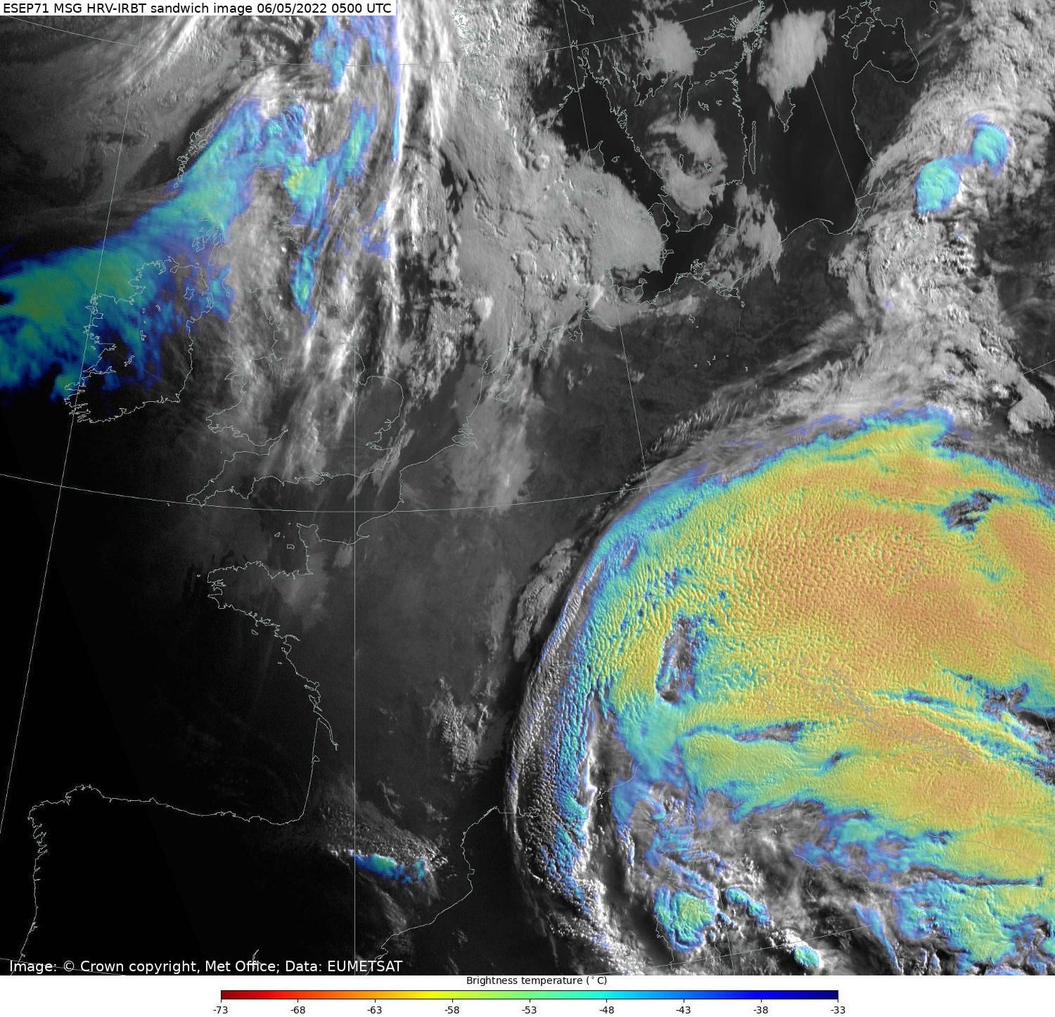
In early May 2022, a large storm carried clouds of Saharan dust northwards, up into central Europe, and also brought distinctive high-altitude cirrus clouds infused with this dust — an example of a so-called Dust-Infused Baroclinic Storm (DIBS) cloud. It is thought that the dust particles act as plentiful ice nuclei in cases such as this, leading to changes in the cirrus clouds' microphysical properties, and lending them the distinctive mottled or "pock-marked" appearance seen in the large area of coloured cloud over central Europe in the image above.
The picture above is an example of a "sandwich" image, incorporating information from both visible and thermal infrared channels from the SEVIRI imaging instrument on board EUMETSAT's Meteosat-11 satellite. The signal from the thermal infrared channel (giving information on the temperature of the cloud tops) is colour coded (as per the legend beneath the image) and made to be transparent, and this is then overlaid onto a high-resolution visible image, so that the physical texture of the cloud-top shows through the coloured infrared temperature signal.
Credits: Images: © Crown copyright, Met Office, Data: EUMETSAT
April 2022 - Von Kármán vortices downstream of the Canary islands
28 April 2022
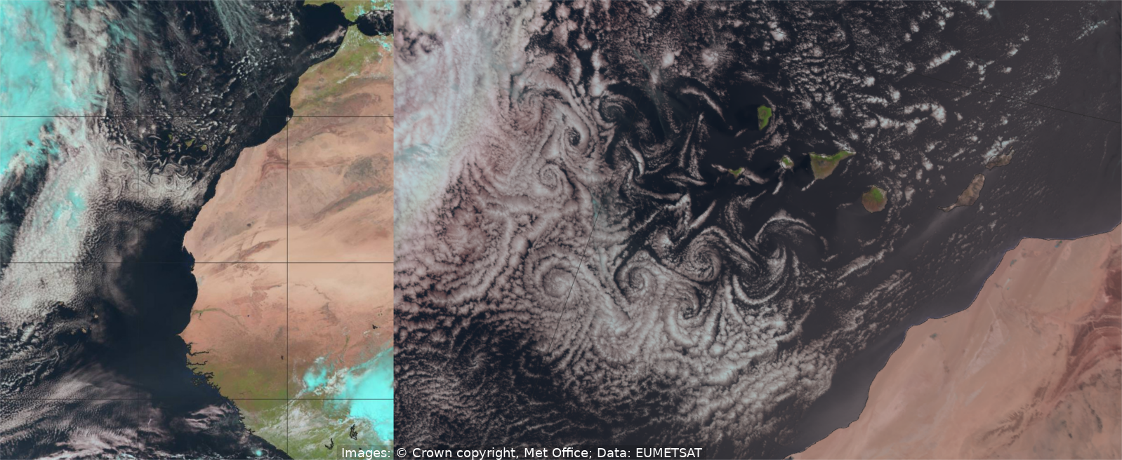
These spectacular cloud streets, known as von Kármán vortices, are formed when a low-level flow of air is disturbed by the presence of an island (or in this case several islands) rising out of the ocean, the diversion of the flow around the island causing spiralling cloud patterns to form downstream. In this case, these clouds were spotted in our satellite imagery during the morning of the 28 April 2022 to the south-west of the Canary Islands.
The left-hand image is created from visible and near Infra-red channels of the SEVIRI instrument on Meteosat-11, a geostationary satellite operated by EUMETSAT (with the combination of channels providing a view near to what the human eye would see, except that ice clouds show up as a cyan colour). The right-hand image shows the equivalent channel combination from the AVHRR instrument on EUMETSAT's polar-orbiting Metop-B satellite at almost exactly the same time. In the latter case, the fact that the satellite is orbiting much closer to the Earth's surface contributes to a higher-resolution image, enabling us to zoom in and see these cloud features in significantly greater detail.
Credits: Images: © Crown copyright, Met Office, Data: EUMETSAT
March 2022 - Saharan dust over Spain and France
15 March 2022
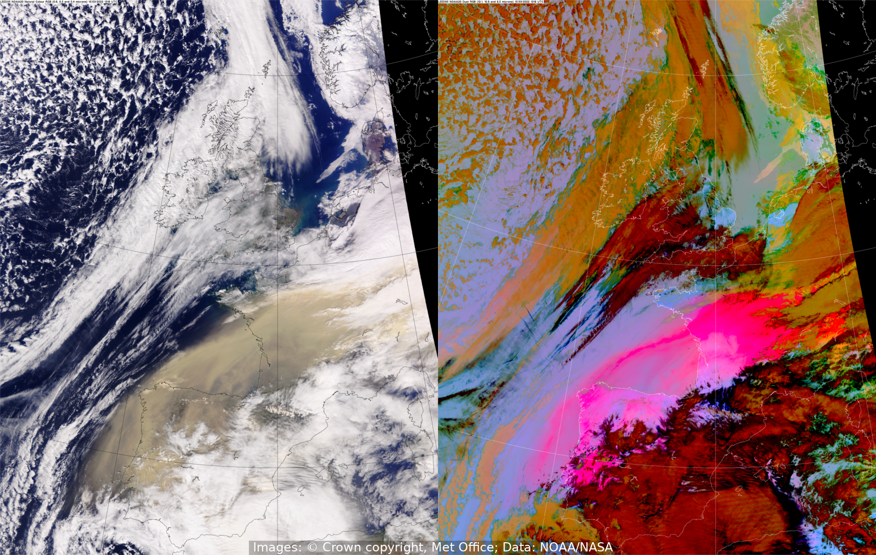
A large cloud of desert dust, created by storms in the Sahara desert, is carried northwards over Spain and France by the wind, as can be clearly seen in this pair of VIIRS satellite images from the NASA/NOAA-operated satellite NOAA-20. Both images show the situation at 1318 UTC on the 15th March 2022. In the left-hand true colour image the dust cloud appears as a sandy light brown colour, whereas in the right-hand image, an infrared false-colour ("Dust RGB") composite, the dust appears as bright pink/magenta colours.
Credits: Images: © Crown copyright, Met Office, Data: NOAA/NASA
February 2022 - Storm Eunice
18 February 2022
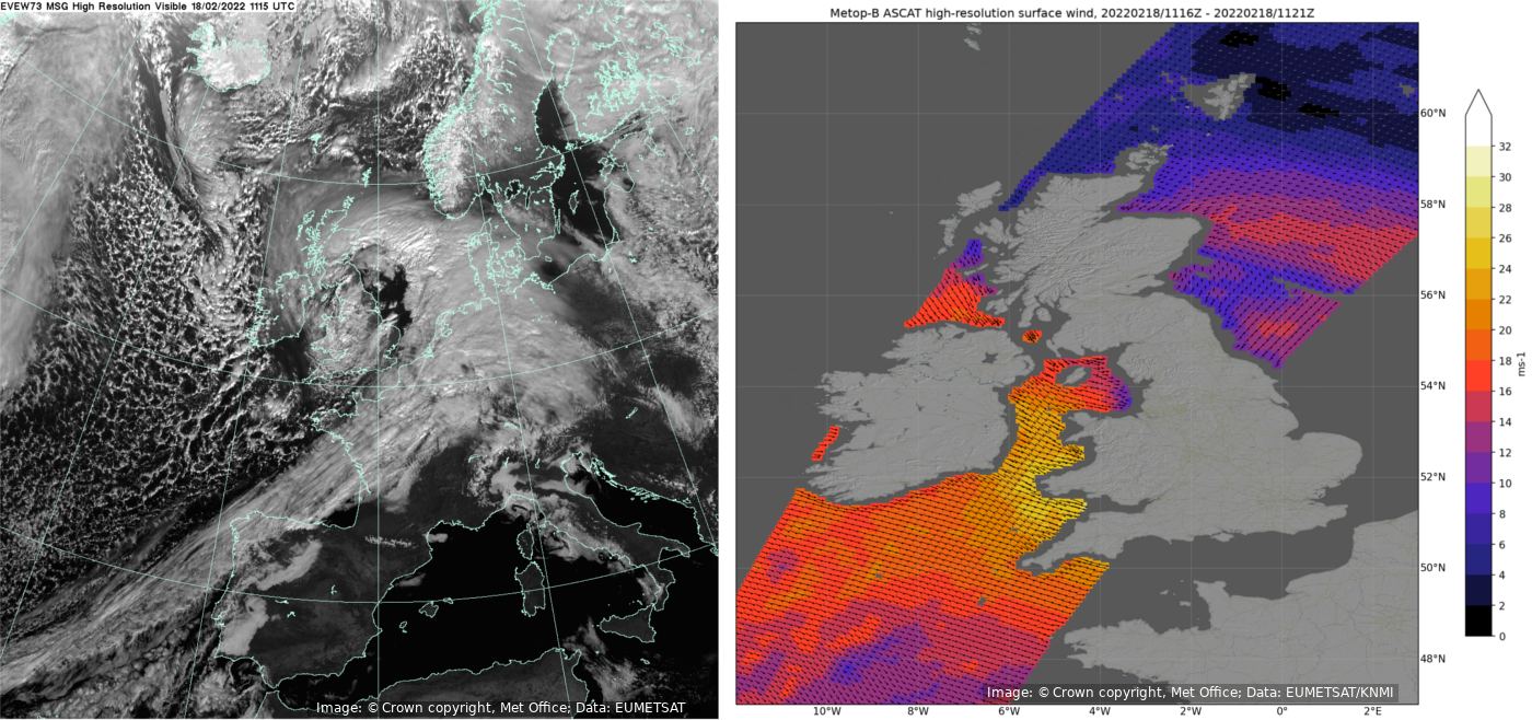
Storm Eunice was named by the Met Office on 14 February 2022, and resulted in the issue of two rare red weather warnings, one for areas of South Wales and South West England and one for London and the South East of England, prior to the storm crossing the UK on 18 February. The left-hand image above shows a visible image taken from the geostationary Meteosat-11 satellite at around 1115 UTC on the morning of 18 February. At a similar time, a wind gust of 122 miles per hour (55 metres per second) was recorded at the Needles, Isle of Wight, provisionally setting a record for the fastest wind gust ever recorded in England.
The right-hand image above shows measured surface winds near the centre of Eunice at a similar time. The colours on the map indicate the instantaneous strength of the wind, with each point representing an average over an area around 30 km across; yellow shades represent the strongest winds (approaching 30 metres per second) for the swath covered, whilst the arrows show the wind direction. These wind data are derived from the Advanced Scatterometer (ASCAT) instrument on-board the polar-orbiting Metop-B satellite. From an orbit of over 800 km above the Earth’s surface ASCAT cannot measure the wind directly. Instead the radar sends down pulses of microwave energy and measures the return signal which is scattered back from the ocean surface. As the wind strength increases the ocean surface becomes rougher and more energy is back-scattered towards the satellite. By taking multiple measurements of the same patch of ocean an estimate of the surface (10 m height) wind speed and direction can be made.
Credits: Images: © Crown copyright, Met Office, Data: EUMETSAT/KNMI
January 2022 - Hunga Tonga-Hunga Ha'apai Eruption
15 January 2022
A submarine volcano, located in the South Pacific Island nation of Tonga, began erupting in late December 2021. Activity built in the following weeks, coming to a head on January 15th with a ferocious explosion in the early hours of the day.
The images above show the eruption on January 15th, captured by GOES-17, a geostationary satellite operated by NASA/NOAA. The images are ‘natural colour RGB’ which uses a combination of visible and near infra-red channels to provide a view close to what the human eye would see, except ice clouds show up as a cyan colour. The left image (04:30 UTC), and right image (05:00 UTC) help illustrate the rapid development of the volcano plume.
Credits:Image: © Crown copyright, Met Office, Data: NOAA/NASA