

World Area Forecast Centre (WAFC)
Here you'll find an overview of a WAFC, what we provide and how it will evolve in the future.
Changes to the T+24 WAFS SIGWX forecasts are now live,please click here to find out more information |
|---|
What is a WAFC
To meet pilots’ needs for meteorological information, in the early 1980s the International Civil Aviation Organization (ICAO) developed the requirements for the World Area Forecast System (WAFS) to include the seamless forecasting of upper air winds, temperatures and significant weather hazards to enhance safety and identify potential for delays.
To provide this information to the aviation community, two World Area Forecast Centres (WAFCs) were established – and remain the only two in the world. One is operated by the National Oceanic and Atmospheric Administration (NOAA) in the USA and the other WAFC is operated by the UK Met Office.
What does a WAFC provide
-
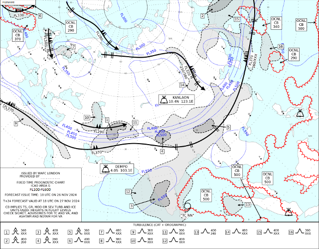
SIGWX forecasts
SIGWX charts are an essential tool for pilots enabling them to get broad overview of the significant weather relevant to their flight. In the below example certain elements can be seen, such as the jet streams (areas where the wind speed exceeds 80 knots), areas of cumulonimbus clouds and turbulence, erupting volcanoes, and tropical cyclones.
-
Global gridded WAFS data sets
In addition to the SIGWX charts we also produce global gridded data sets of wind and temperature which can be used to create efficient flight plans, and also gridded data sets of hazardous phenomena such as cumulonimbus cloud, clear air turbulence and icing. This data can be integrated into, and visualised by, flight planning software and play a key part in the decision-making process.
Full details of the WAFS data sets that are made available via SADIS can be found on our SADIS pages:
WAFC Performance
As a World Area Forecast Centre, our performance is verified across a range of different regions to ensure the accuracy of our forecasts. Find out more about our WAFC London performance indicators.
The future of WAFS
As World Area Forecast Centres (WAFCs), the UK Met Office and National Oceanic and Atmospheric Administration (NOAA) are working collaboratively to ensure that the next generation of WAFS data sets deliver accurate and improved meteorological data to the rapidly changing aviation industry, in line with operational objectives in the ICAO’s Global Air Navigation Plan (GANP) and the Aviation System Block Upgrades (ASBU). These new and improved data sets will contribute towards limiting the environmental impact of air travel, cope with increased traffic and capacity demands and help air traffic management strategies to mitigate against and avoid hazardous weather conditions.
For information on upcoming changes please see our Aviation Services LinkedIn page, which will be updated periodically about the WAFS upgrades and other service information.
Get in touch
Call us
We are available 24/7.
0370 900 0100Email us
Fill out this short form and we'll get back to you.
Contact Us formFollow us
Linkedin XGet in touch
Call us
We are available 24/7.
0370 900 0100Email us
Fill out this short form and we'll get back to you.
Contact Us form